
This presentation is a contribution to the discussion about the future of semantic technologies, and more specifically the discussion about the proposed Topic Maps Reference Model. In this paper I will attempt to show that the terms which are used to describe the work being done in the semantic technologies are somewhat misleading, and I will propose using the term "perspective" instead of the term "ontology" to emphasize the fact that the vision of semantically integrated information depends on the point of view adopted. In this paper I will show that the traditional approach (top-down) which looks like the natural and reasonable thing to do when dealing with information models doesn't work efficiently as long as what we are interested in is connecting information from various and heterogenous sources.
Keywords: Semantic Web; Topic Maps; Interoperability
| XML Source | PDF (for print) | Author Package | Typeset PDF |
Philosophically speaking, an ontology is a "science or study of being: specifically, a branch of metaphysics relating to the nature and relations of being; a particular system according to which problems of the nature of being are investigated; first philosophy." [COR1]
In computer science, "an ontology is the attempt to formulate an exhaustive and rigorous conceptual schema within a given domain, typically a hierarchical data structure containing all the relevant entities and their relationships and rules (theorems, regulations) within that domain." [WIK1]
Using the philosophical term in the computer science context has a misleading effect: it conveys the idea that it is in the nature of things that they are the way we describe them. However, although things do exist, they cannot be described without a specific worldview, be it implicit or explicit. Therefore there are various ways to describe the same thing, each of which is valid in its own right. Variations may be due (among other reasons) either to the fact that the descriptions have been created by different unrelated authors, or that they apply to different contexts, or that they serve a different purpose and are intended to be used by different categories of users...
As we have learned from experience, particularly when designing document structures, there is usually not a single way to describe things and sometimes there are no compelling reasons to decide whether one particular way should be considered better than another. Semantic applications only make it worse, since there may be several ways to speak about the same thing. [SHI1] It appears to be necessary to take into account multiple perspectives.
Kim H. Veltman gives this definition of semantic interoperability:
Semantic interoperability is the ability of information systems to exchange information on the basis of shared, pre-established and negotiated meanings of terms and expressions.[VEL1]
According to this definition, semantic interoperability works best in an environment where systems are able to communicate together and if there is a one to one correspondence between statements-- essentially, where systems conform to a single ontology. This can be achieved in a variety of cases, as is illustrated by various applications which are done under the Semantic Web umbrella, but it can't generally work for information systems that have not been prepared to interoperate.
Semantic integration is the grouping of information items organized around shared subjects. The definition of what delimits a subject is a matter of perspective. In a given perspective, several information items will be considered the same subject whereas in another one they may be distinguished because the level of granularity of the description of information is finer.
It is useful to distinguish several layers that are at work: "thing", "subject", "proxy", "interpretation", "perspective", "view". In this paper I propose to consider the following definitions, which is my way of illustrating the concepts of the proposed Reference Model for Topic Maps.[TMRM1]1
A thing is considered to exist in the universe, independently of any observer. It has no name, no description, it simply is. We can't even talk about it. A thing is not really interesting as such, since there is nothing anybody can do with it.
A subject is an understanding of a thing. A subject is the process of conceptualizing a thing. This is different from the definition that the current Topic Maps standard gives of a subject: "In the most generic sense, a subject is any thing whatsoever, regardless of whether it exists or has any other specific characteristics, about which anything whatsoever may be asserted by any means whatsoever." In the current presentation, a subject is not a thing any more, it is a way to understand it. A subject is a way to make sense of a thing. It is pure meaning. This is where the semantic universe begins.
Each subject is expressed via a proxy. The proxy can be a name, a text, an oral phrase, a picture, a file, a URI, that is aimed at representing a subject. A proxy is therefore an information object, that can be analyzed and processed according to rules. Linguistic analysis can be used to evaluate proxies, computers can be used to compute and store proxies, etc. The proxy is an object, that has named properties and values for each of these named properties. The proxies may have names, description. This is where the computer world begins. A given set of proxies is called a "subject map".
An interpretation consists in creating an expression for a subject. Since there are unlimited ways to express subjects, there can be many different expressions for the same subject. Two different people will generally describe the same subject in slightly different ways, even when they agree that they are describing the same subject. They can also represent the subject using different languages. There is never a single way to express a subject. The world of interpretation is unbounded, and it is the human world, marked by the curse of the Tower of Babel. The ability of everybody to express subjects according to his or her own way is also the basis for freedom of speech, and it is a prerequisite for democracy.
Each interpretation of any subject is made within a certain perspective. A perspective is a bias in which the universe is seen that determines the expressions that are uttered to describe it. In a given perspective, subjects are expressed using a given classification, and by applying a given set of rules. The classification schema and the set of rules used are either implicit or explicit. If computerized, they can be made explicit when they follow a model, such as the entity-relationship model. Sometimes they are explicit but remain hidden from the end user. The set of rules and algorithms used by search engines to gather information relevant to a given subject are explicit for those who created the engine, but they are not exposed. Each taxonomy, which is a hierarchical organization of proxies, uses a given perspective. Any ontology is no more and no less than a perspective, because it is made of a set of rules by which proxies are related and computed against each other. It seems that using the word "perspective" is clearer and more precise than using the word "ontology". The word "perspective" conveys the idea that the expression of proxies representing subjects is somewhat "subjective". A perspective can also be described as a filter or a stylesheet for knowledge. Perspectives are creating by uttering the patterns that subject proxies must comply with. Subject patterns express rules for determining when two subjects should be considered the same (identification rules) and rules for merging subject proxies once subjects have been recognized as identical.
The reason for creating perspectives is to provide views. A view is a set of proxies treated as a unit. It is the result of applying a subject pattern. A view is a particular output which fits particular user needs. The same subjects can be filtered through different perspectives and will end up be presented in completely different views. A parallel can be drawn with the markup principle: "one source, several outputs". One set of subjects, several views.
Semantic integration is the process by which plurality is reduced to uniqueness. It is used as input the plurality of expressions that can exist for a given subject. It aims at creating views in which subjects that have been expressed with different proxies appear to be the same. These views are made under pre-defined perspectives. This means that subject proxies that merge in one perspective may not merge in another one.
The Topic Maps Reference Model introduces a distinction between subject identification rules and merging rules. Subject identification rules serve to define when two different proxies correspond to the same subject, whereas merging rules serve to define what to do with the properties of proxies when they are merged. Subject identification rules are a component of what has been described here as a perspective. Each perspective can be considered a topic maps application and an ontology. By calling an ontology a perspective, we emphasize the fact that this is a thing that is done "after the fact", and is highly customizable to fit a particular model of how we want to see things. By calling them "ontologies", we seem to indicate that these are things as they are, in their very essence. "Perspective" implies plurality, whereas "ontology" implies singularity.
Implementing an ontology, like a database management system, or an XML application, is usually perceived as a top-down approach. The architecture has to be defined before anything can be done. This approach works for information islands, where the complexity of the structure is simple enough to enable a small team of people to agree on a common ground. Semantic integration, on the other hand, allows for connecting information that was not at the start envisioned to be connected. Using a perspective-based approach enables highly customized integration and a bottom-up approach. This opens powerful new ways to put information together, provided we abandon the requirement to have every layer in the process under control.
There are many possible illustrations of examples where using multiple perspectives will offer a workable solution. The major interest of such solutions is that they don't require any change to the existing management of information. The diversity of perspectives is respected, and new perspectives are created, each corresponding to a given category of usages. Integration of information comes as a result of mapping, it doesn't require source information materials to be altered. This approach leverages existing information rather than requiring it to be restructured.
Typical use cases include situations where an organization or several interconnected organizations (such as government agencies) need to cooperate. If there is an overall schema aiming at connecting information from various sources, the size and the amount of existing information assets to be interconnected is very diverse and very large. Consequently, having everybody agree on a single ontology that would cover all needs at various levels is an unachievable task. Using multiple perspectives in such a context is mainly a matter of common sense: less ambitious, more specific, goals are easier to achieve. Still, they can be connected on demand to answer certain needs.
An example is the connection between topics involving Federal regulations and their counterparts at the state level in the United States (or European level/national levels, or Government/Provinces in Canada). Information returned may be identical, derived, slightly different, or radically different, and it needs to stay like this. A single ontology would never capture all nuances, and filtered views are necessary.
The usual message coming from the standards community is: make data interoperable! merge your maps! This seems to be so common-sense that there is no point in discussing the rationale for doing it. The only interesting discussion is how to best achieve this objective. Actually, interoperability is far from being achievable in most cases, without first transforming the data. This is similar to performing experiments in the context of quantum mechanics, where there can be no observation without altering the environment and conditions that are being studied. Merging seems to be more lame, because it can be done by creating a supplementary layer and letting the previous states remain unchanged. But still the analysis of real-world situations makes us wonder whether things which in appearance should merge should actually merge. The notion of perspective, which imposes a user-view, is sometimes more important than the information content itself, and merging too extensively may be eventually counter-productive, because too much information is being aggregated and it prevents us from using the information in an efficient manner.
The examples presented here are subject maps rendered as graphical maps. These are multiple maps of the same territory, each expressing a different perspective. The perspective can be analyzed by looking at what the map actually displays. Some of the maps express perspectives which result from the merging of other maps. The important point that will be emphasized is the fact that merging is not necessarily the ultimate goal, and the way it is done depends on how it fits specific, well-defined, user needs.
A series of (topic) maps of Lower Manhattan are going to be presented
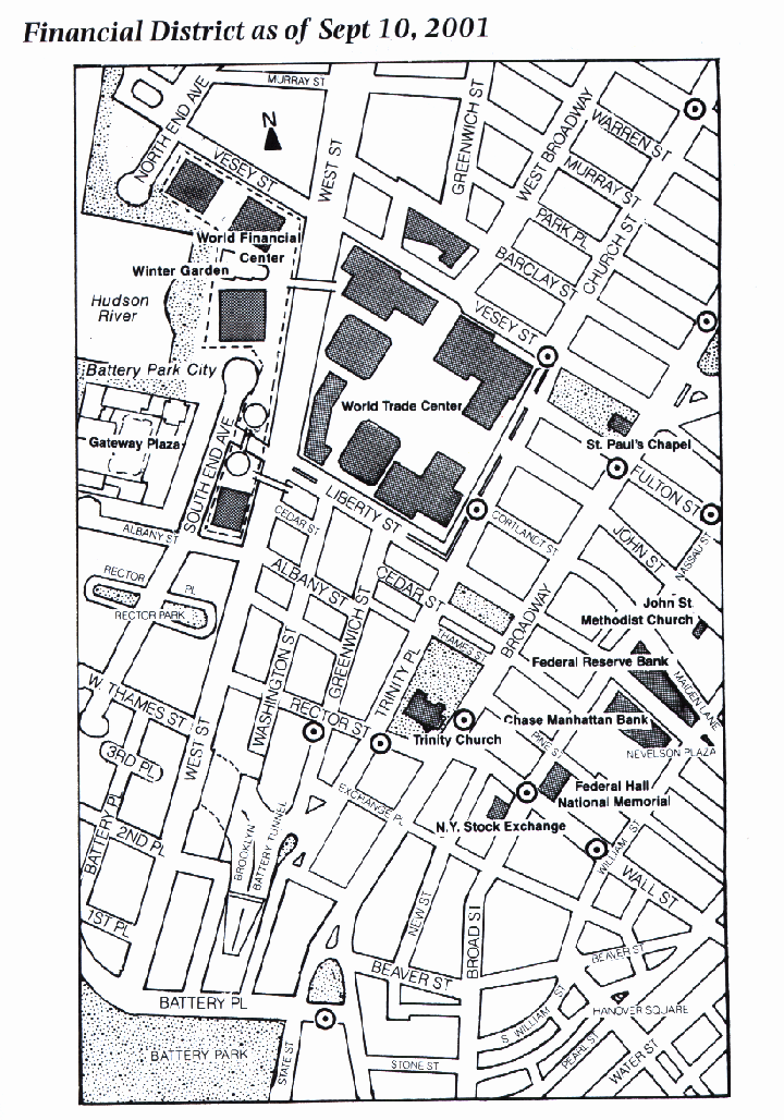
This map supports a text that describes the landmarks and sightseeings of the neighborhood.
City Guide, New York, Carol von Pressentin Wrigh, Stuart Miller and Sharon Seitz, A.&C Black Limited/W.W. Norton & Co. Inc., 3rd Ed., 2002
This is a simple street map, actually difficult to use when reading the book. This map does not have much information, and some of it is not optimized. For example, the subway stops are marked with circles, but these are not informative.

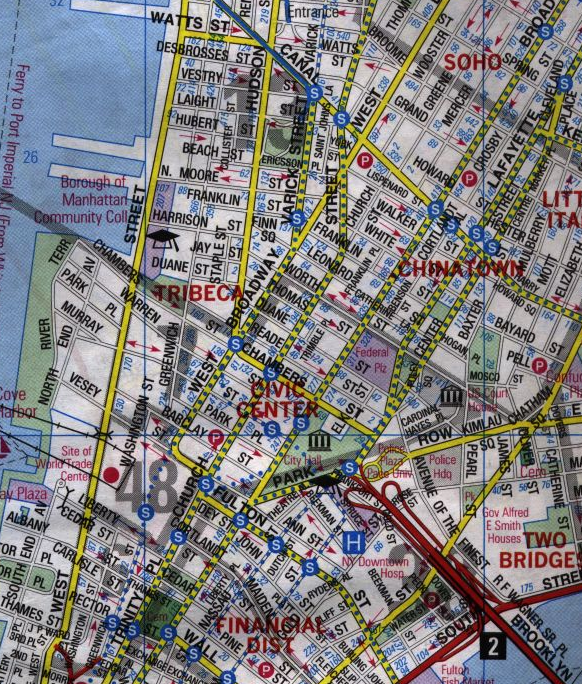
This map shows several itineraries for sightseeing.
New York, Michelin, 8e ed., 1989
This map can be used as a table of contents for various chapters of the guide. Although the scale is not very detailed, this map contains enough to have an idea of the overall distance, and also it shows the alternate itineraries nearby. This map is probably not detailed enough to be used alone. Another more detailed map may be necessary.
This map has no transportation information associated.
This map is aimed at French-speaking tourists. Some of the text is translated into French (the expressions which have made their way in the language).
Although it has fewer details than the previous map, it may be actually friendlier to use.
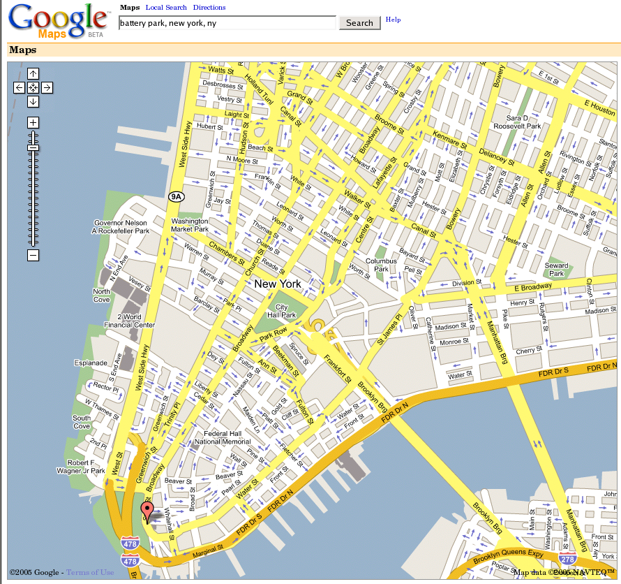
This map is a complete street map which is used on the Web to find a specific location, or directions from one location to another one. The zoom level can be adjusted. Other similar maps exist which offer comparable services. They are mainly used when seeking directions for driving to a given location.
Google provides satellite pictures together with its maps, which show exactly the same area. These pictures are spectacular, and interesting from a geographic point of view. It is interesting to note though that this picture doesn't really give a good idea of the height of the buildings. It is not clear what use it has apart from satisfying mere curiosity and aesthetics. It clearly plays a role in differentiating Google from its competitors, who don't provide satellite maps.

This map is distributed to tourists. Its features include information which is allegedly useful for tourists: landmarks, museums, parks, architectural sites, restaurants, hotels and subway stations.
Downtown New York, Downtown Alliance, www.DowntownNY.com, 2/02
The way this map has been designed corresponds to a merging of the two preceding maps. It is treated as an aerial photograph but also contains the street names.
However, its usability is not obvious. Again, it's difficult to get an idea of the height of the buildings from the map.
The fact that the location of hotels is indicated is certainly useful. The indications of the restaurants' locations is more questionable. There is no guarantee that all restaurants for example are mentioned, and we don't know what criteria have been used to select some of them.
The major objective of this map seems to be political. It aims at showing that Downtown Manhattan is reviving after September 11. It is still a thriving area, has a lot to offer for tourists.
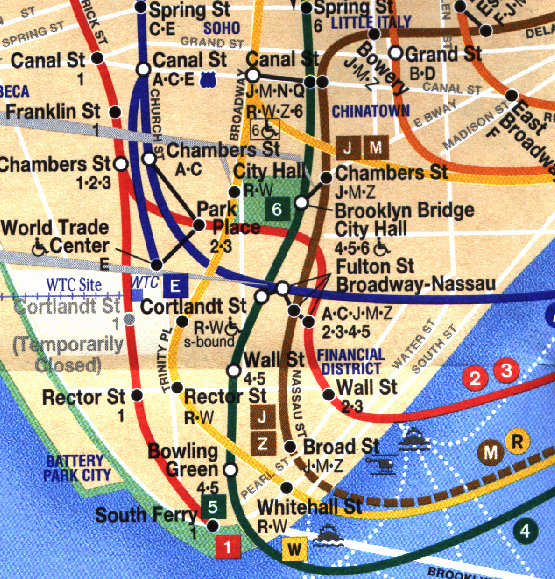
This is one of the maps mostly used by New Yorkers to find their way in the five boroughs.
New York City 5 Borough Pocket Atlas, Hagstrom, 2001.
The Map, MTA Metropolitan Transportation Authority, May 2005 Edition
This subway map features routes, stations, and transfer points, indicates police stations and elevators, and distinguishes between express, local, and rush hour only service.
The scale is not accurate, because this map has been optimized for readability.
Note that ferry service is also represented.
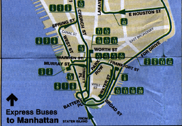
Manhattan Bus Map, MTA, New York City Transit, February 2004.
Bus maps should be simple. They should be street maps displaying the bus routes running on every street.
However, the situation is more complex. Even for MTA buses, there are at least 5 maps that describe Lower Manhattan buses. 4 of them are presented here. They are based on the following implicit knowledge:
City buses serve the 5 New York City boroughs. Downtown Manhattan buses serve (at least) Manhattan, Brooklyn and Staten Island. There are two kinds of buses: local buses and express buses. Not only don't they look the same, but they have different fares, and the rules for riding them are different. For example, it's not possible to board an express bus and use it for local stops.
The first map shows the local buses in Manhattan serving Manhattan (and Brooklyn).
Note that subway routes and stops are represented. The advantage over the "official subway map" is that these maps are to scale. The drawback is that it's not possible to see where routes are going outside of Manhattan.
Brooklyn Bus Map, MTA, New York City Transit, February 2004.
This map represents both the subway and bus routes connecting Manhattan to Brooklyn. Both Express and Local buses are represented on this map.
These two maps represent the express bus routes connecting Manhattan and Staten Island. Since there are many bus routes, and they follow different itineraries in both directions (to and from Manhattan), there are 2 different maps to represent them. Therefore there is not one but two Staten Island perspectives.

Staten Island Bus Map: Express Buses to Staten Island.
Staten Island Bus Map, MTA, New York City Transit, December 2002.
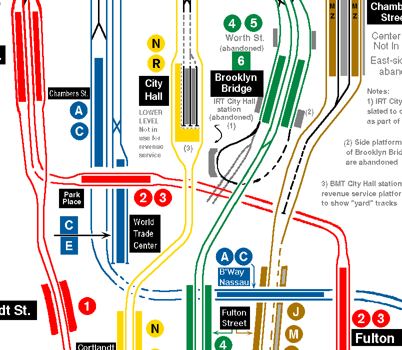
Interborough Rapid Transit Company, http://www.nycsubway.org/perl/caption.pl?/maps/historical/railways1906-54.gif
This map represents the IRT subway network and elevated network in 1906. Note that there is a station called "Worth Street".
The track map represents the current track map. It contains some historical information (abandoned stations, such as Worth Street, for example). This map can be used to figure out where tracks are going. It doesn't show what transfers are available between subway lines.
This map can be used not only by railfans but also for the maintenance of the track network. It also are interesting for purposes of security on the subway network.
Other maps are likely to be available for maintenance of the subway network. They are not publicly accessible.
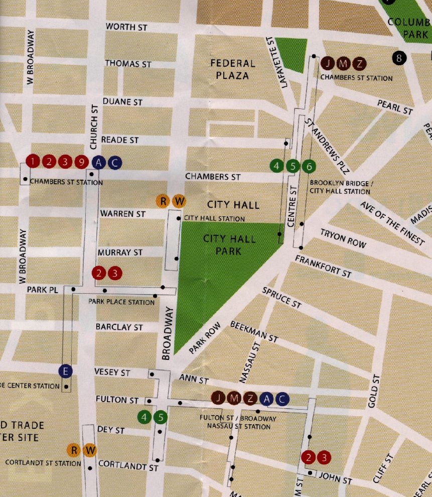
Explore Chinatown New York City. www.ExploreChinatown.com, 2005.
This map merges the street map with the subway map and displays information which neither of the preceding maps shows. It shows where entrances to the subway system are located in the streets, as well as transfers which are available between subway lines. It is helpful to minimize the walking to get to a subway station, and can also be used to choose between different itineraries. It also shows that some stations that are not interconnected are indeed very close to each other.
This map is interesting but the level of detail makes it unlikely to be usable at full scale for the whole system. Also, despite the fact that it contains very useful information about the subway stops and their exact location, it doesn't show the subway routes. The other subway map is still necessary to get the full picture.
Other maps are available for the same area, which correspond to other needs. The two following slides show other maps that locate utility and administrative features that are useful for reconstructing the World Trade Center site, for example, and for managing some of the services offered by the city.
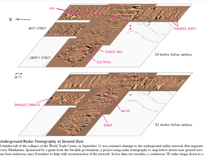
Lower Manhattan Underground Radar Project, http://www.lowermanhattan.info/construction/global/contact/
The subway system is not the only underground facility. This map shows the damage to the Utility network after the terrorist attacks of September 11.
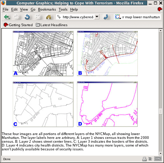
Computer Graphics: Helping to Cope With Terrorism. By Ben Delaney (C) 2002. This article originally appeared in IEEE Computer Graphics and Applications January/February 2002, http://www.cyberedge.com/3a1_020331_a.html
This maps shows four layers, among others that cover the same area: 2000 Census tracts, 2000 Center lines, Fire Districts, City Health Districts. The intersection of some of the layers are useful for operational purposes. Firemen for example need to know how the city is divided into health districts to direct people in need to the appropriate facilities of their district.
From what has been shown here, it may be that the answer is: what for?
On the one hand, it would be nice to have all information relevant to a given territory connected together. It seems rational to do so. The layered model presented in the previous graphic seems to be an appropriate answer. This layered model could be merged and used as a management tool. It is also a discovery tool that enables queries to be performed on various aspects. Harmonization of these aspects could lead to the formulation of a common model that would contain common goals.
On the other hand, the information overload of such a merged approach would be daunting. Merging all these layers would necessarily lead to losing focus on what are the important aspects that need to be privileged. The absence of specific perspective would equate to losing relevance and precision in the information. The complexity would increase, because the level of precision of each of these maps differs, and we don't necessarily have enough information to determine where exactly things match together. The maintenance of such an information base would also be made much more difficult, given the fact that many aspects of these layers are interconnected. In addition, achieving such a level of interoperability between the layers would require agreements on each of these aspects, and agreement might be prevented because of possible conflicting requirements.
Semantic interoperability relies on having a well-defined perspective. There is no other way to achieve it. Computers need to understand each other, and that means that everything, down to the most minuscule details, needs to be expressed in such a way as to prevent bottlenecks from occurring during the transition process between various environments. Here we are speaking of a single perspective, which may be distributed over several systems, located in various places, but the overall design, the structure, and the semantic used should be common. Despite the fact that systems could be large, very far from each other, they should all rely on a common architecture, built on one perspective, to function properly. In this environment, computers deal with objects, and these objects may or may not represent semantics, but this is not important. They end up being reducible to unique identifiers, be it URIs (or rather now IRIs to accommodate various alphabets), XML identifiers, digital object identifiers, or Public Subject Identifiers. We are speaking here of a potentially large, but closed, universe.
Semantic Integration on the other hand corresponds to a situation that is at the opposite end of the spectrum. Here we are speaking of information that allegedly represents some meaning, not always totally explicit, and that can be expressed in an infinite number of ways. Diverse information can co-exist even in very close environments, in the room next door, or even on the same computer system. Of course inside an organization examples abound of information that has semantics that could be interconnected but for some reason is not. This is an environment where an infinity of variant perspectives exist, some of them may not even be defined explicitly. This is the "real" information world, as opposed to the previous world which is all pre-processed. And it is much more challenging to try to find ways to make meaning emerge out of this messy information magma, rather than to tailor everything in a way that would reject anything else. Here we are in an all-inclusive environment. Any information, even information not initially meant to be interconnected, should be interconnectable, one way or the other. This is what semantic integration is really about.
The objective of this paper has been to demonstrate that the first step to achieve this daunting goal is to recognize the multiplicity of perspectives. In other words, once some meaning has been uttered, there is a perspective behind it, whether we recognize it or not. It is by looking at the rules that have been applied while creating this piece of information, and by disclosing the rules that are at work -- rules for establishing identity of meaning, rules for applying merging to identical subjects, and derived rules, if any -- that we can provide hooks that can be used as binding points for other, similar, pieces of information. But sometimes we can't access the original perspective that was at work while creating the information. Never mind! What counts is the perspective through which we are viewing the information we are interested in. It is biased, naturally, but recognizing it makes things simple, and open. If for some reason this bias is not appealing, or not adapted, nothing prevents us from creating another one which is more appropriate. And the reality is that this is what we are doing constantly, whether we recognize it or not.
Using the word "perspective" in lieu of "ontology" helps us understand this issue, which may turn out to be critical. The meaning of information has not a lot to do with what computers can make out of it. Computers don't get the meaning, they just apply algorithms. It's time to recognize that artificial intelligence is not what we're looking for. We should be more and more aware of the illusionary aspects that computers present. Search engines are maximally useful, and we couldn't live without them any more. But they are not providing us with value that is outside of their own, closed, well-defined, usually proprietary domains. Some information users need more than that.
The problem with subjects is that they are eventually not really computable. What gets to computers is only their proxies. And the relation between subjects and proxies is not a simple one-to-one. The whole issue of perspective comes in the middle of that, along with the difference between top-down, closed, semantic-web oriented, machine-computable semantics, on the one hand, and bottom-up, open, ambiguous, diverse, semantics of information on the other hand. I believe this confrontation is going to be the major challenge for the years to come.
|
Many of the ideas I am presenting have emerged from discussions with Steven R. Newcomb, who doesn't necessarily agree with my conclusions. |
[COR1] Raul Corazzon, What is Ontology?, http://www.formalontology.it/section_4.htmmailto:raul.corazzon@formalontology.it in http://www.formalontology.it/index.htm, Ontology, A Resource Guide for Philosophers.
[SHI1] Clay Shirky, Ontology is Over-rated: Categories, Links and Tags http://www.release1-0.com/freshproduce/article.cfm?serialnum=FRP200505312301
[TMRM1] Patrick Durusau, Steven R. Newcomb, The Topic Maps Reference Modelhttp://www.isotopicmaps.org/tmrm/
[VEL1] Kim H. Veltman, Syntactic and Semantic Interoperability: New Approaches to Knowledge and the Semantic Web, The New Review of Information Networking, vol. 7, 2001 www.sumscorp.com/articles/pdf/2001%20Syntactic%20and%20Semantic%20Interoperability.pdf
[WIK1] Ontology (computer science) http://en.wikipedia.org/wiki/Ontology_(computer_science)


